Explore Software for Drones

Clear All

Data Analytics

Data Processing

Enterprise Solutions

Flight Mission Planning

Geographic Information System

UTM/ANSP

-- Category Introduction Section -- (These comments are only for code understanding and will not appear on the website)

Explore Drone Softwares

The drone industry has evolved beyond flight hardware, with sophisticated drone software solutions becoming the central nervous system of modern unmanned systems. At BeyondSky, we understand that professional-grade software is critical for optimizing performance, ensuring regulatory compliance, and transforming raw data into actionable intelligence. Our B2B marketplace is dedicated to helping you discover, compare, and procure the most advanced drone software tailored for every industry and application.

Whether you are a drone manufacturer, an enterprise operator, or a deep tech innovator, our platform offers a comprehensive catalog of solutions. From essential flight control systems and intricate mission planning tools to advanced data analytics and robust regulatory compliance software, we connect you with the tools you need to maximize efficiency and drive business value. Explore our curated selection and unlock the full potential of your drone operations.

-- Accordion Section: Tips & Guides --

Buyer Tips: How to Choose the Right Drone Software Solutions

Selecting the right drone software is a strategic decision that impacts the entire operational lifecycle. Here are key considerations for professionals in the drone industry:

1. Flight Control Systems:
Look for solutions that offer real-time telemetry, advanced safety features, and a user-friendly interface. Ensure compatibility with your existing drone hardware and consider features like geo-fencing and automated flight modes for enhanced safety and efficiency.

2. Mission Planning:
A robust mission planning tool should provide detailed flight path creation, obstacle avoidance, and pre-flight simulations. Tools with multi-rotor and fixed-wing support, as well as offline planning capabilities, are invaluable for complex or remote missions.

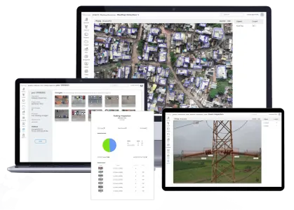
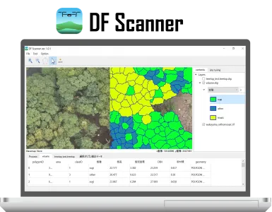
3. Data Processing & Analytics:
Evaluate software based on its ability to process various data types (e.g., photogrammetry, LiDAR, thermal) and its integration with industry-standard GIS and CAD software. Data analytics features, such as automated object detection and change analysis, are crucial for extracting maximum value from your data.

4. Fleet & Maintenance Management:
For large-scale operations, software that offers centralized management of drone fleets, pilot logs, and maintenance schedules is essential. These platforms help maintain compliance and ensure operational readiness, while also providing valuable insights into asset utilization.

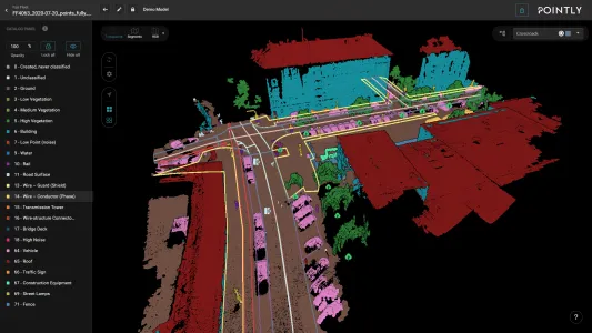
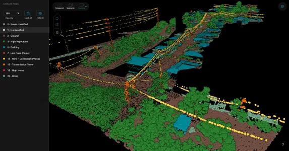
5. Mapping & Surveying Tools:
Prioritize software that can generate high-precision 2D orthomosaics, 3D models, and digital elevation maps. The ability to export data in multiple formats for seamless integration with other software is a key feature for professionals.

-- Parts/Components Description Section --

UAV Software Across Drone Operations

Effective drone operations rely on a suite of software tools that work together seamlessly across different mission stages.

Pre-Flight Planning

Before a drone leaves the ground, sophisticated UAV software is used to ensure mission success and safety. Tools for mission planning allow pilots to define flight paths, set camera parameters, and verify airspace regulations. Weather analysis and compliance software assist in mitigating risks and securing necessary permissions, forming the foundation of a safe and efficient flight.

During Flight Execution

During a mission, flight control systems provide the pilot with real-time data and command capabilities. These systems monitor critical parameters such as battery life, altitude, and signal strength. Advanced software can also automate flight tasks, enabling the pilot to focus on data collection and situational awareness.

Post-Flight Value Creation

Once the drone lands, the real value creation begins. Data processing and analytics software transform raw imagery and sensor data into meaningful outputs like 3D models, high-resolution maps, and detailed reports. These tools are critical for turning flight data into actionable insights for clients and stakeholders.

Drone Software for Specific Use Case

Specialized industries require specialized drone software companies to address their unique challenges.

  • Agriculture: Software for agriculture leverages drone imagery to create detailed crop health maps, detect pest infestations, and analyze soil conditions. Solutions often integrate with farming equipment and farm management systems to enable precision agriculture, optimizing resource use and improving crop yields.
  • Survey and Mapping: In this sector, photogrammetry and LiDAR software are essential for generating accurate 2D and 3D models of terrain and structures. These tools are used for volumetric calculations, construction progress monitoring, and creating detailed topographical maps that are critical for engineering and urban planning projects.
  • Mining Industry: UAV parts and software are used in mining for tasks such as stockpile volume measurement, pit slope stability analysis, and infrastructure inspection. Software in this sector must be capable of handling large datasets and integrating with mine management systems to support efficient, safe, and compliant operations.
Why Choose BeyondSky for Drone Software

As the premier B2B platform for unmanned systems, BeyondSky offers unmatched access to global markets, with an ecosystem of trusted suppliers, integrators, and drone software companies. We offer both free and premium subscription plans to facilitate quality connections and visibility.

From sourcing innovative new drone software to evaluating supplier credibility, our platform is built to simplify how you find and buy drones software—with certified listings, technical documentation, and dedicated buyer support. We provide a single, professional hub where you can make informed decisions and connect with the best solutions on the market.

-- Question and Answers Section --

Buyer Guide / FAQs