- Subscription Plans
- Favorite
- Help
-
 English
-
English


Provide drone operators with up-to-date information on ground hazards, air restrictions, and prohibitions related to the drone's location and altitude.
About Geo-Awareness
Provide drone operators with up-to-date information on ground hazards, air restrictions, and prohibitions related to the drone's location and altitude. The geo-awareness service is available through REST APIs, which can be accessed both during mission planning and in real time during flight execution.
The geo-awareness service is tailored for specific customer operational zones and requires API integration with the customer's backend system and/or application. It is designed for U-space Service Providers (USSPs), UTM Service Providers (USPs), drone application developers, drone manufacturers, and, more broadly, companies operating drones that need accurate maps and services.
The geo-awareness API encompasses five API endpoints, respectively:
The location of the planned drone mission should be provided in the request. Additional parameters, such as altitude, can also be included in the request and specified in either MSL (Mean Sea Level) or AGL (Above Ground Level) terms. Each search returns one or more JSON objects representing an area defined by a bounding box on the ground. These objects contain all relevant information for that specific area, including prohibited zones, restricted zones, maximum authorised flight altitude, potential warnings, converted altitude, and type of restriction.
More technical details available on the developers zone.
The geo-awareness API is provided as a Supplemental Data Service. However, it is not a substitute for obtaining flight authorization from relevant regulatory authorities.
About Us
Stratomaps was founded by Yvan Montalieu, who has a background in mapping, Location-Based Services for terrestrial mobility. Over the past two decades, he has assisted numerous companies in incorporating maps and geospatial services into their products, while also leading teams of geospatial platform developers. The decision to venture into aerial maps and services stemmed from recognizing the potential of digitized ground objects and hazards to produce valuable aerial map data for drones. This complements the existing restrictions and prohibitions set by national civil aviation authorities. Adding the third dimension, altitude, to typical geospatial services, presents complexities, but it also brings exciting new challenges.
Yvan has successfully rallied a small team of algorithm experts and developers who are enthusiastic about addressing these new challenges. Beyond the intellectual fulfillment of pioneering new technologies for UAS, the team shares a common mission: to enhance operational safety, reduce carbon emissions, and mitigate societal impacts.
Maps and Location-Based Services for Drones
In a world where the use of Unmanned Aircraft Systems is becoming prevalent to perform safety, rescue, infrastructure surveillance, and delivery missions; access to high-quality maps and real-time Location-Based Services is critical to plan and execute flight operations safely and in compliance with regulations.
Stratomaps addresses these emerging needs by processing and aggregating ground hazard and airborne data, and providing it to drone operators as geospatial services through a suite of APIs.
Our Mission
Stratomaps was born out of the belief that we stand on the brink of a new era, where Unmanned Aerial Vehicles will become a mainstream mode of transportation. The growing use of drone activities Beyond Visual Line of Sight (BVLOS), such as large scale infrastructure surveillance, rescue operations, delivery of medical supplies, and Urban Air Mobility, will only be permitted by authorities if they pose minimal airborne, ground risks and annoyance to the population.
Our mission is to develop technologies that will help to improve safety of operations, reduce carbon emission and mitigate societal impact.
We believe we can help improve safety by:
- providing awareness services
- computing routes that minimize risks
We believe we can help reduce carbon emission by
- computing optimal routes
- optimizing deliveries and infrastructure inspection missions
We believe we can help mitigate societal impact of drones by
- recommending routes that limit public disturbance
- defining new maps with dedicated UAV corridors
Services
1. Altitude Helper
Altitude helpers and terrain following to convert Above Ground Level flight paths into Mean Sea Level or drone’s Home referential.
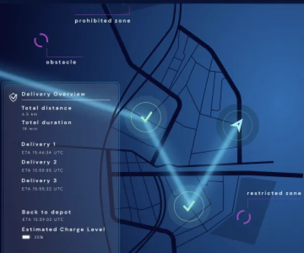
2 Route planning
Commute the shortest route for flights operating Beyond Visual Line of Sight, taking into account ground hazards, air restrictions and prohibitions.
3 Route optimization
Optimize the assignment of drones to jobs for infrastructure inspections or deliveries, taking into account the specific constraints of both drones and jobs.
4. Geo-awareness
Provide up to date air and ground information to the drone's operators about restrictions and prohibitions in relation to the drone's location and altitude.
5. Geo-caging
3D virtual cages generated for a given zone or in a corridor along the drone's route. The virtual cages can be used to raise different levels of alerts and automate emergency actions.
6. Route validation
Load the trace of the planned route and validate that it does not intersect with any ground hazards, prohibited, or restricted zones.

Stratomaps
Software
Maps for Drones, Altitude Maps, Geo Awareness, Route Optimization Software, Route Planning Software
Software Solutions
Aerial Photography, Construction & Real Estate, Disaster Management / First Responders, Drone Delivery, Infrastructure & Transport, Power & Utilities, Security & Law Enforcement, Supply Chain & Logistics, Surveillance & Mapping
France
France
In a world where the use of drones is becoming prevalent to perform safety, rescue, infrastructure surveillance, and delivery missions; access to high-quality maps and real-time Location-Based Services is critical to plan and execute flight operations safely and in compliance with regulations. Stratomaps addresses these emerging needs by processing and aggregating ground hazard and airborne data, and providing it to drone operators as geospatial services through a suite of APIs.


