- Subscription Plans
- Favorite
- Help
-
 English
-
English
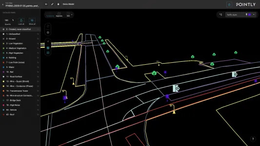
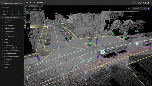
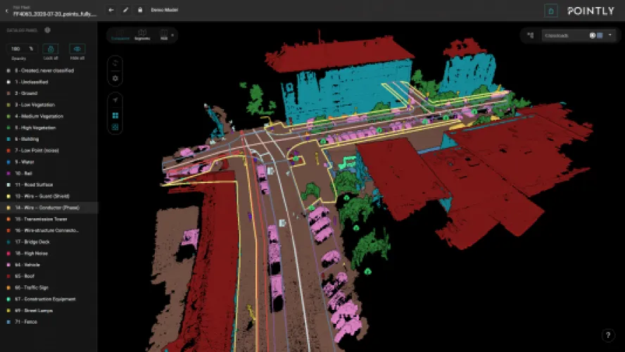
You now have access to a comprehensive toolbox for drawing vector models in your point clouds. Easily vectorise your point clouds within Pointly’s intuitive web interface, enabling a seamless workflow and increasing the precision and efficiency of your projects.
Make use of our intuitive toolbox to:
- Place Points
- Draw Polylines
- Create Polygons
The Pointly Plattform offers ever user now access to a comprehensive toolbox for drawing vector models in your point clouds. Easily vectorise your point clouds within Pointly’s intuitive web interface, enabling a seamless workflow and increasing the precision and efficiency of your projects.
Make use of our intuitive toolbox to:
- Place points
- Draw polylines
- Create polygons
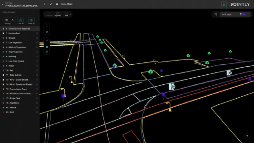
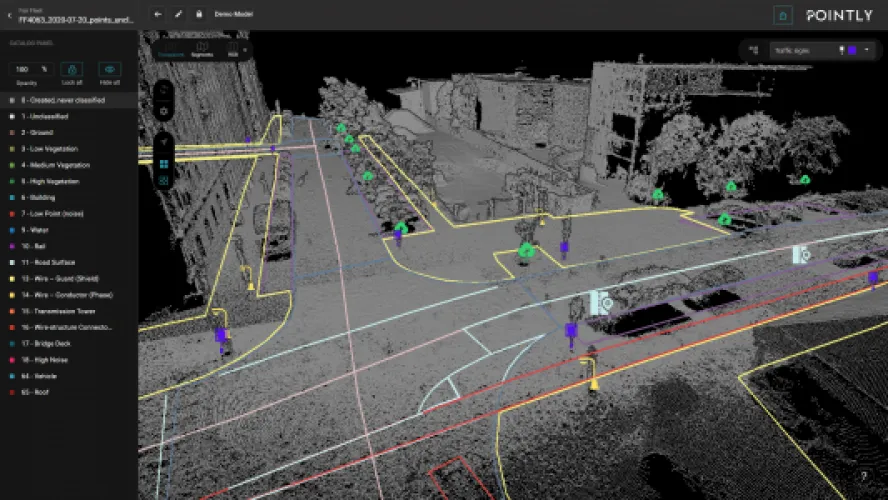
Our layer management allows for cleaner vector models and easy organization of the elements within them.
Picture this: effortless categorization of your point cloud data into layers like Trees, Parking spaces, Road surfaces, Road markings, and Traffic signs. Each layer contains precise 3D elements, painting a clearer picture of your point cloud.
Tailor layers to your liking by selecting colors and icons that suit a variety of applications – all directly within the Viewer. Watch your visualization come to life with a personal touch.
Navigate through layers seamlessly using the intuitive drop-down menu in the Vectorization Settings panel. Easily identify and work with the active layer, streamlining your element placements.
Easily create new layers and modify existing ones, allowing for efficient project management. Each layer has a unique identity—name, color, and icon—to improve clarity and streamline workflows.


Pointly
Services
3D Pointcloud: Classification (automated via AI & manual tools), vekotization tools and tailormade coustum solutions
Software Solutions
Aerial Photography, Construction & Real Estate, Forestry & Agriculture, Infrastructure & Transport, Mining & Exploration, Power & Utilities, Surveillance & Mapping
Germany
American Samoa, Australia, Bouvet Island, Brunei Darussalam, Cambodia, China, Christmas Island, Cocos (Keeling) Islands, Cook Islands, East Timor, Fiji, French Polynesia, Guam, Hong Kong, Indonesia, Japan, Kiribati, Lao, Malaysia, Marshall Islands, Micronesia, Federated States of, Mongolia, Myanmar, Nauru, New Caledonia, New Zealand, Niue, Norfolk Island, North Korea, Northern Mariana Islands, Palau, Papua New Guinea, Philippines, Pitcairn, Samoa, Singapore, Solomon Islands, South Korea, Taiwan, Thailand, Tokelau, Tonga, Tuvalu, Vanuatu, Vietnam, Wallis and Futuna Islands, Albania, Andorra, Armenia, Austria, Azerbaijan, Belarus, Belgium, Bosnia and Herzegovina, Bulgaria, Croatia (Hrvatska), Cyprus, Czech Republic, Denmark, Estonia, Faroe Islands, Finland, France, French Southern Territories, Georgia, Germany, Gibraltar, Greece, Greenland, Guernsey, Hungary, Iceland, Ireland, Isle of Man, Italy, Jersey, Kazakhstan, Kosovo, Kyrgyzstan, Latvia, Liechtenstein, Lithuania, Luxembourg, Monaco, Montenegro, Netherlands, Norway, Poland, Portugal, Romania, Russian Federation, San Marino, Serbia, Slovakia, Slovenia, Spain, Svalbard and Jan Mayen Islands, Sweden, Switzerland, Tajikistan, Turkey, Turkmenistan, Ukraine, United Kingdom, Uzbekistan, Vatican City State, Latin America & Caribbean, Middle East & North Africa, North America, South Asia, Angola, Benin, Botswana, Burkina Faso, Burundi, Cameroon, Central African Republic, Chad, Comoros, Congo, Equatorial Guinea, Eritrea, Ethiopia, Gabon, Gambia, Ghana, Guinea, Guinea-Bissau, Ivory Coast, Kenya, Lesotho, Liberia, Madagascar, Malawi, Mali, Mauritania, Mauritius, Mayotte, Mozambique, Namibia, Niger, Nigeria, Reunion, Rwanda, Sao Tome and Principe, Senegal, Seychelles, Sierra Leone, Somalia, South Africa, St. Helena, Sudan, Tanzania, Togo, Uganda, Zambia, Zimbabwe
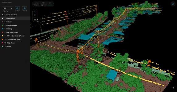
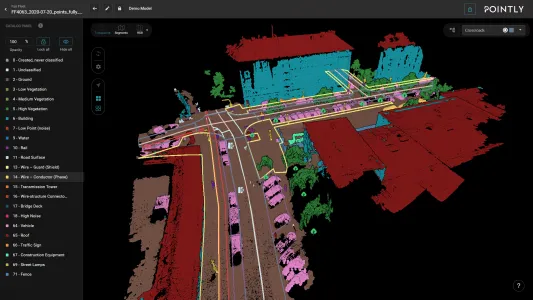
Pointly is a cloud-based and user-friendly 3D classification platform for all types of point clouds. It offers automatic as well as manual classification for fast training data generation for AI Use Cases. Since the last ubdate also manual vekotizations tools. Combined with Pointly Services, where we offer tailormade 3D point cloud solutions (e.g. automated feature extraction or CAD data generation), we can support you with your projects from proof of concept to fully scalable solutions.