World's first B2B marketplace for the global drone industry.

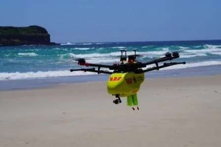
Beyond Sky is on a mission to bring the global actors of the drone industry and its consumers, on a single platform. No cost to consumers. No Commission on Business Transactions. No hidden fees.

Clear All
Advertisement Banner

Explore by applications

How it works

english-flag English
|
french-flag French

What’s new

  • axl Orbit GNSS system for UAVs with real-time high-precision tracking

    axl Orbit-N GPS/Next-Gen GNSS & 1.5m Accuracy

    Axldrone

    GNSSPrecisionNavigation
    View Product

    axl Orbit-N GPS/Next-Gen GNSS & 1.5m Accuracy

    Axldrone

    axldrone axl Orbit-N GPS with No Cover, Ultra-Superior Accuracy upto 1 Metre, Built for UAVs, Surveillance, and Defense sectors, 100% Made in India.

    Superior Accuracy : Achieve up to 1-meter precision for optimal navigation.                                                                                                                       
    Multi-GNSS Capability: Supports BeiDou,GLONASS, Galileo, and GPS for enhanced reliability. 
    Integrated QMC5883L Compass: Ensures precise orientation and navigation assistance. 
    Lightweight & Durable: Encased in an environmentally controlled heat shrink for reduced weight and easy installation. 
    Optimized for Critical Applications: Built for UAVs, surveillance, and defense sectors.
    100% Made in India with non-Chinese components under the Make in India program 

  •  axl oneView Remote Controller - High-Performance Industrial Drone Control

    axl oneView, India’s First WPC Certified Remote

    Axldrone

    Remote Controller CertifiedTouch Screen
    View Product

    axl oneView, India’s First WPC Certified Remote

    Axldrone

    axl oneView is India’s first WPC-certified remote controller designed for professional drone operations. It features ultra-long-range video transmission, encrypted multi-interface connectivity, and an intuitive user experience, making it the most advanced ground control system available today.

  • axlperegrine Aircraft - Advanced Industrial Drone with AI & 4K Camera

    axl Peregrine, Advanced Industrial Drone

    Axldrone

    Industrial ApplicationsSurveillance & MappingQuadcopter
    View Product

    axl Peregrine, Advanced Industrial Drone

    Axldrone

    Sturdy, long-lasting Carbon Fiber Quadcopter Airframe, crafted with precision and passion, offering an unparalleled aerial innovation experience.

  • Euradrones certified aerial data and analysis platform

    Verifiable Aerial Data for Strategic Decisions

    EURADRONES

    DroneDataGeospatialAIBlockchainCertification
    View Product

    Verifiable Aerial Data for Strategic Decisions

    EURADRONES

    Euradrones offers a comprehensive suite of drone services, including advanced image processing, detailed 3D modeling, robust blockchain certification, and precise geospatial analysis. We also provide GNSS network solutions, AI-powered image analysis, and real-time data diffusion.

  •  International Drone Show in Odense

    International Drone Show 2025

    Odense Robotics

    ExpositionLive DemoB2B Networking
    View Product

    International Drone Show 2025

    Odense Robotics

    International Drone Show (IDS) features drone demonstration flights, insights on relevant drone industry topics, inspiring talks from experts and an elaborate exhibition for you to get in touch with the right contacts at the right time. 

  • AI-powered Digital Twin solution for drones & IoT applications.

    Digital Twin TwinARC

    Enterprise Minds

    Digital TwinTwinARCFailure Prediction
    View Product

    Digital Twin TwinARC

    Enterprise Minds

    Digital Twin TwinARC is a multi-tiered solution that provides routine digital twin functions such as condition monitoring and failure prediction but also adds high-value CAUSAL digital twin that we call "MIC" digital twin.

  • Fire Eagle drone detecting wildfire in forest

    Fire Eagle Drones for Forest Fire Detectection

    MENAPS

    Forest FireAIAutonomous
    View Product

    Fire Eagle Drones for Forest Fire Detectection

    MENAPS

    Detects forest fires in under 5 minutes and autonomously alerts fire brigades in real time, covering vast areas 24/7.

  • Dragonfly DS-1 by Overspace Aviation

    Dragonfly DS-1 by Overspace Aviation

    Overspace Aviation

    High EnduranceBVLOSLong Range
    View Product

    Dragonfly DS-1 by Overspace Aviation

    Overspace Aviation

    Dragonfly DS-1 represents the flagship product of Overspace Aviation. Its unique and patented design and high technological content guarantee exceptional performance in any scenario and with any flight condition.

  • GeoDrones 4D

    GeoDrones 4D

    GeoDataLab

    DroneTechnologyGeospatial Innovation FleetManagement
    View Product

    GeoDrones 4D

    GeoDataLab

    GeoDrones 4D, developed by GeoDataLab, offers an advanced solution for real-time drone fleet management and monitoring. The system features a simulator to generate flight paths and a 2D/3D viewer for real-time tracking, ensuring efficient and precise drone operations.

  • Geodatalab product GeoCloudSDI: Advanced Spatial Analysis Platform

    GeoCloudSDI by GeoDataLab

    GeoDataLab

    DroneTechnologySpatialAnalysisGIS
    View Product

    GeoCloudSDI by GeoDataLab

    GeoDataLab

    GeoCloudSDI by GeoDataLab is an innovative WebGIS platform designed for professionals in urban planning, environmental management, emergency management, and geomarketing. Powered by GeoNode, Mapstore, and GeoServer, this solution offers advanced spatial analysis tools for identifying spatial correlations and optimizing pathways. Integrated with reliable territorial databases, GeoCloudSDI delivers comprehensive insights and ensures interoperability with other GIS platforms, making it an essential tool for the drone industry and beyond.

  • Vololand VLS Theo Docking station

    VLS THEO: Automated Drone Docking Station

    Vololand

    Docking StationBVLOSBattery Swap
    View Product

    VLS THEO: Automated Drone Docking Station

    Vololand

    VLS THEO is an advanced automated docking station designed for industrial and commercial drone operations. Featuring autonomous landing, battery swapping, and data transfer capabilities, this station enables drones to perform continuous missions with minimal human intervention. 

  • Vololand Small docking station

    Battery Swapping Small Drone Station VLS SION

    Vololand

    Docking StationAutonomousBattery Swap
    View Product

    Battery Swapping Small Drone Station VLS SION

    Vololand

    Drone solutions are key infrastructure that supports industrial drone operations. This station is responsible for the drones charging, automatic takeoff and landing and data communication. Through the battery automatic charging and replacement function, the drone can perform repetitive autonomous mission flights, and with the precision landing guidance capability, the drone can always land accurately and safely at the station.

Advertisement Banner

Find our top brands

  • UASolution
  • Enterprise Minds
  • EV-Peak
  • T Motor
  • EVA
  • Openskies Aerial Technology
  • Renice
  • Vstream Revolution
  • DMD Solutions
  • Drone Design Lab
  • Drone Fusion
  • Air Courtage Assurance
  • ELBIT Systems
  • LogiXair
  • AV Drone Consluting
  • DroneDeck
  • Wing Flying
  • Flight Deck
  • Skydrone Robotics
  • TSAW
  • DeepForest
  • Hastin Energy
  • Pointly
  • AeroMegh
  • Indrones
  • JR-UAV
  • Reflex Drive
  • PhoenixAI
  • Aeron Systems
  • Stratomaps
  • HNTE Marketing Media
  • Ecole Nationale de l'Aviation Civile
  • UAM Consultant
  • Commercial UAV Expo
  • Aerospace Valley
  • h-aero
  • Drona Aviation
  • Synerex
  • Orqa FPV
  • ABZero
  • Vololand
  • DroneLab Aviation
  • STC Labs
  • Widdel
  • GeoDataLab
  • droneAI
  • Euradrones
  • axldrone
  • BEILab

Discover our features

  • Advance Search Filters Advanced filters
  • Customer Ratings Icon Customer ratings
  • Lead Generation Task Generate Leads
  • Communication Forum in Beyond Sky Open
    Forum
  • Beyond Sky tenders Jobs and InternshipsJobs and Internships

Upcoming Events

  • Geospatial World Forum

    Geospatial World Forum

    Exposition, Conference

    GWF has become a not-to-be-missed conference for the professionals engaged in geospatial and allied sectors.

    Apr 22, 2025 Madrid Spain
  • EUROCAE Symposium 2025

    EUROCAE Symposium 2025

    Symposium, Awards, Networking

    Annual symposium, which gathers participation from highly specialised experts and top industry leaders from Europe and globally.

    Apr 23, 2025 Madrid Spain
  • Drone Expo 2025

    Drone Expo 2025

    Conference, Exposition

    The exhibition will cover all aspects of UAV and drone technology, Components, and Anti Drone Technology.

    Apr 24, 2025 Hyderbad India
  • MOSA for Defense Summit

    MOSA for Defense Summit

    Exposition, Conference

    Forum to discuss the warfighting imperative of implementing a MOSA approach in the design, development acquisition, and sustainment of modern systems.

    Apr 30, 2025 Washington, DC USA
Advertisement Banner