- Subscription Plans
- Favorite
- Help
-
 English
-
English


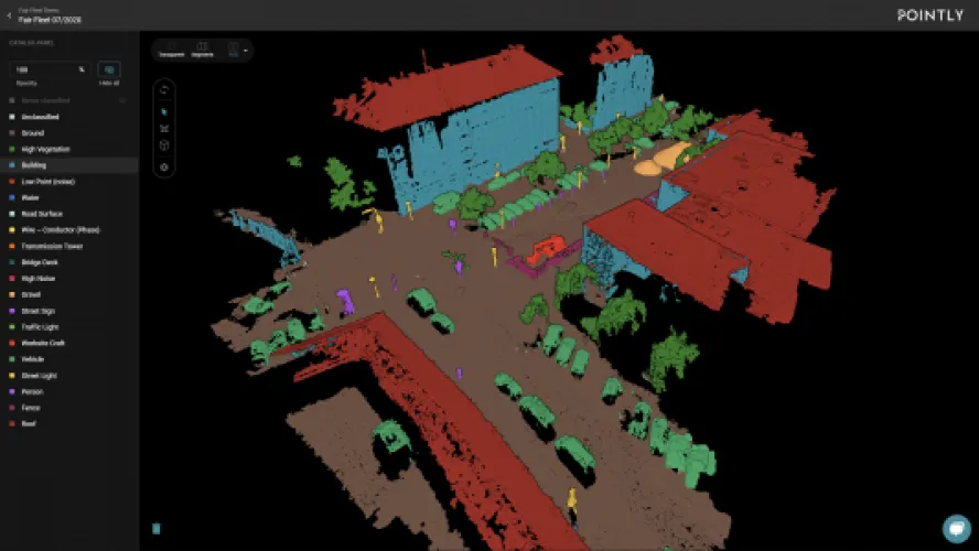
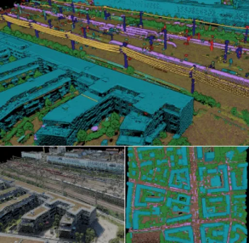
Pointly offers efficient point cloud object classification using innovative AI techniques.
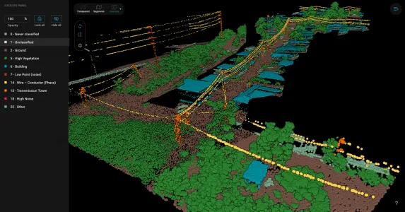
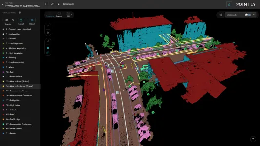
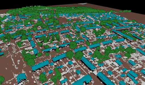
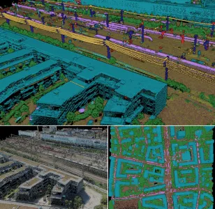
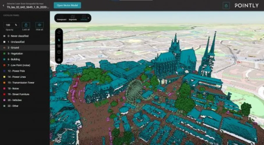
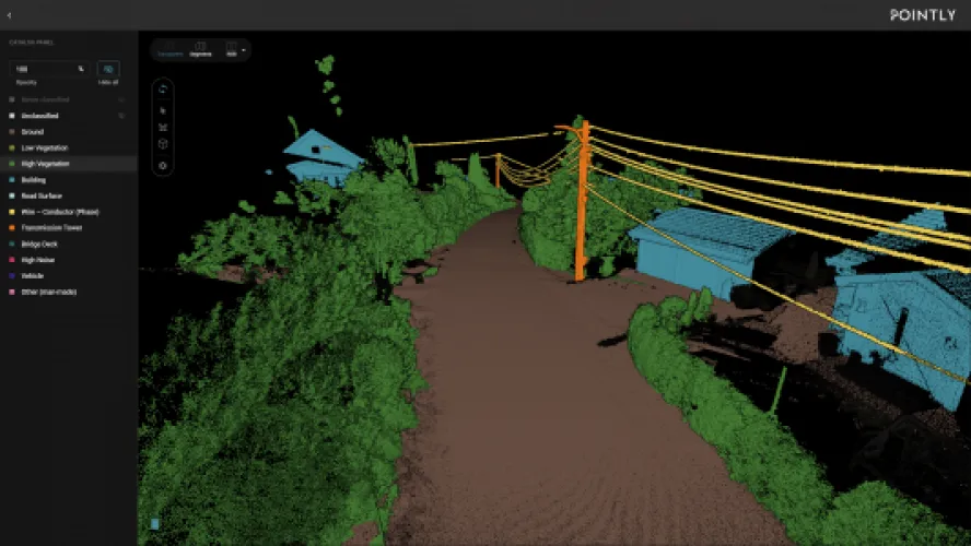
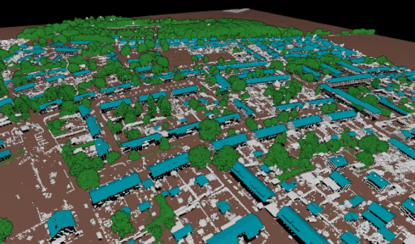
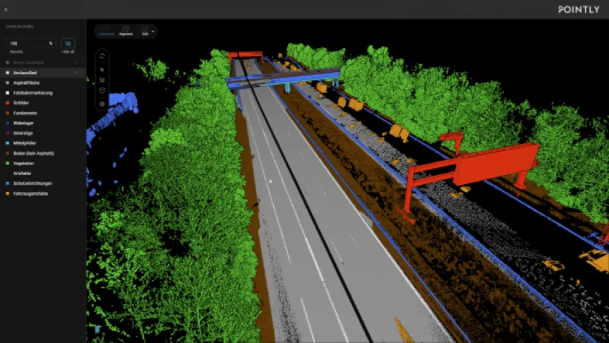
Standard classifiers, based on deep learning, automatically categorize point clouds for common use cases like Airborne Laser Scans, City Inventories, and Highway Scans.
Custom classifiers provide tailored solutions for unique data requirements, ensuring accurate classification.
Using innovative AI approaches, points that belong together can be selected with minimal effort and high accuracy. With the automatically pre-processed segments, you can apply classification to complex objects with just a few clicks.
By building on deep learning, we train standard classifiers for semantic segmentation. With a steady input of training data, the standard classifiers will be able to automatically classify your point clouds for certain use cases such as:
Benefit from automatic point cloud object classification right upon uploading your data.
Make use of our Pointly 3D Point Cloud Services to train a custom classifier, should our standard classifiers not meet the requirements of your cloud data. Our custom classifiers are trained explicitly for the specific needs of our clients.
These classifiers are fully customizable for the proper visualization and analysis of your data. By supplying it with enough information, the custom classifier is able to automatically recognize the fitting class for your point cloud on upload.
We also offer Training Data Generation as Labeling Services to create the perfect alignment of training data and AI model.
Pointly uses Microsoft’s fast, flexible, and secure Azure Cloud Computing Services. The parallel processing architecture allows elastic and independently scalable processing of even extensive amounts of data.
Everything you need to use Pointly is Internet access and a browser. No installation is required – simply sign up and benefit from the power of cloud storage and computing.
There is no need to invest in building data centers, external hardware, or maintenance. “Point out what matters to you,” right out of the box.
Your data is safe with us. Building on Azure’s 256-bit AES encryption standard and advanced threat protection, we protect your information whether in storage or transit.
Your user identity is managed through Azure B2C and ensures that only you have access to your data.
Pointly allows multiple individuals to access a project or point cloud simultaneously. Share it with your clients or your team – our tool allows you to perform classifications on various point clouds at once from several end points.
Streamline work processes by applying tags to:
Via an API you can access the point cloud classification to utilize standard as well as custom classifiers without using the Pointly interface. The classification models can also be implemented into other platforms.
Instead of using the Pointly point cloud classification through a cloud, you can also order the standard or custom classifiers as a software package on-premise, allowing you to directly run it on local computers on client side.


Pointly
Services
3D Pointcloud: Classification (automated via AI & manual tools), vekotization tools and tailormade coustum solutions
Software Solutions
Aerial Photography, Construction & Real Estate, Forestry & Agriculture, Infrastructure & Transport, Mining & Exploration, Power & Utilities, Surveillance & Mapping
Germany
American Samoa, Australia, Bouvet Island, Brunei Darussalam, Cambodia, China, Christmas Island, Cocos (Keeling) Islands, Cook Islands, East Timor, Fiji, French Polynesia, Guam, Hong Kong, Indonesia, Japan, Kiribati, Lao, Malaysia, Marshall Islands, Micronesia, Federated States of, Mongolia, Myanmar, Nauru, New Caledonia, New Zealand, Niue, Norfolk Island, North Korea, Northern Mariana Islands, Palau, Papua New Guinea, Philippines, Pitcairn, Samoa, Singapore, Solomon Islands, South Korea, Taiwan, Thailand, Tokelau, Tonga, Tuvalu, Vanuatu, Vietnam, Wallis and Futuna Islands, Albania, Andorra, Armenia, Austria, Azerbaijan, Belarus, Belgium, Bosnia and Herzegovina, Bulgaria, Croatia (Hrvatska), Cyprus, Czech Republic, Denmark, Estonia, Faroe Islands, Finland, France, French Southern Territories, Georgia, Germany, Gibraltar, Greece, Greenland, Guernsey, Hungary, Iceland, Ireland, Isle of Man, Italy, Jersey, Kazakhstan, Kosovo, Kyrgyzstan, Latvia, Liechtenstein, Lithuania, Luxembourg, Monaco, Montenegro, Netherlands, Norway, Poland, Portugal, Romania, Russian Federation, San Marino, Serbia, Slovakia, Slovenia, Spain, Svalbard and Jan Mayen Islands, Sweden, Switzerland, Tajikistan, Turkey, Turkmenistan, Ukraine, United Kingdom, Uzbekistan, Vatican City State, Latin America & Caribbean, Middle East & North Africa, North America, South Asia, Angola, Benin, Botswana, Burkina Faso, Burundi, Cameroon, Central African Republic, Chad, Comoros, Congo, Equatorial Guinea, Eritrea, Ethiopia, Gabon, Gambia, Ghana, Guinea, Guinea-Bissau, Ivory Coast, Kenya, Lesotho, Liberia, Madagascar, Malawi, Mali, Mauritania, Mauritius, Mayotte, Mozambique, Namibia, Niger, Nigeria, Reunion, Rwanda, Sao Tome and Principe, Senegal, Seychelles, Sierra Leone, Somalia, South Africa, St. Helena, Sudan, Tanzania, Togo, Uganda, Zambia, Zimbabwe
Pointly is a cloud-based and user-friendly 3D classification platform for all types of point clouds. It offers automatic as well as manual classification for fast training data generation for AI Use Cases. Since the last ubdate also manual vekotizations tools. Combined with Pointly Services, where we offer tailormade 3D point cloud solutions (e.g. automated feature extraction or CAD data generation), we can support you with your projects from proof of concept to fully scalable solutions.