- Subscription Plans
- Favorite
- Help
-
 English
-
English


| Higher Accuracy | Orthomosaic images ground distance 1.5 CM/pixel generated |
| Saas Model | Pay Per Consume model. No need to invest licensing cost |
| Fast Processing | It is cloud powered with full scale parallel processing |
| AI Security | Offers AeroCapture service which helps AI based analytics images generated |
| One Stop Solution | Supported products, AeroGCS KEA which helps flight plan & upload data |
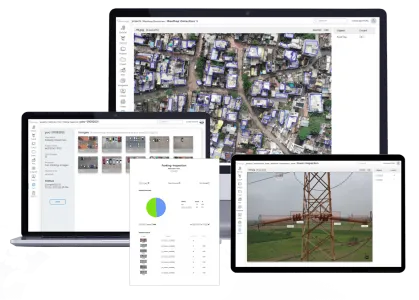
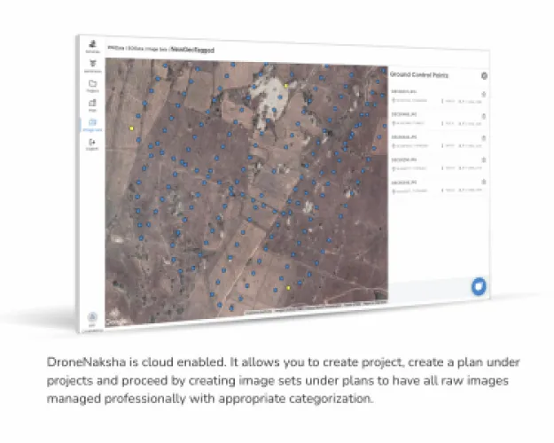
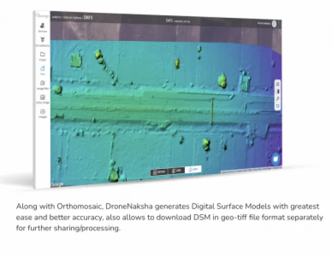
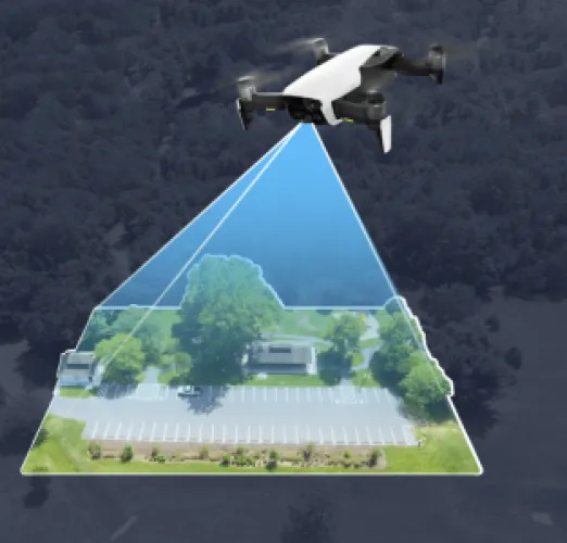
DroneNaksha is designed with a thought of delivering one of its kind, drone survey and mapping experience. DroneNaksha is a SaaS (Software as Service) from AeroMegh platform for various photogrammetry solutions. Along with orthomosaic, DroneNaksha also generates other data types like Digital Surface Model, Digital Elevation Model, Vegetation using various photogrammetry algorithms.
PDRL is a Software Company offering AeroMegh as a SaaS platform for Transforming Drone Data into Actionable Insights. AeroMegh is designed to deliver an End-to-End stack for Flying and Capturing, Processing and Analyzing. AeroMegh allows to carry challenging tasks by saving important aspect of life, Time and Money by resulting in Creating More Time to Live.
Creating More Time to Live for Everyone
We at PDRL think, simplicity brings freedom, freedom to focus on what matters most. Simplicity in technology makes your life and business fun, so we focus on creating simple yet powerful solutions for drone industry creating more time to live. While creating this social value, we are aiming to generate wealth of $15 billion in next 12 years for our people, partners, and investors.
What we do ?
DroneNaksha is designed with a thought of delivering one of its kind, drone survey and mapping experience. DroneNaksha is a SaaS (Software as Service) from AeroMegh platform for various photogrammetry solutions. Along with orthomosaic, DroneNaksha also generates other data types like Digital Surface Model, Digital Elevation Model, Vegetation using various photogrammetry algorithms.
Step 1 : Upload Image
Upload using AeroGCS KEA to simplify your work.
Step 2 : Add GCP
GCP in respective Images and add GCP for orthomosaic generation.
Step 3 : Process And Notification
Click Process button to trigger get notification of completion.
Step 4 : Share Reports
Various types of reports is available, Download and Share.
Applications
Land Survey and Mapping
Process drone captured images, generate orthomosaic, digital surface model, digital elevation model, vegetation index of land area and your survey/mapping job is accomplished. DroneNaksha delivers GSD (Ground Sampling Distance) accuracy up to 1.5 CM / pixel.
Construction and Planning
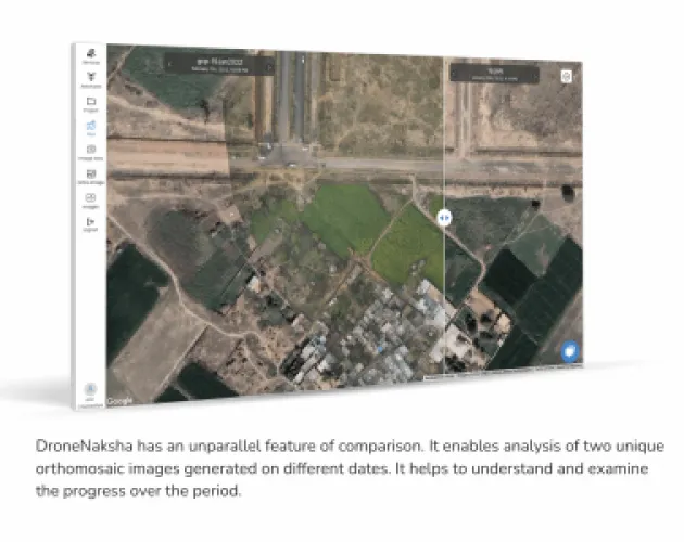
Construction progress monitoring using visual comparison analysis feature of DroneNaksha helps to understand site progress over the period of time. It’s 3D model gives a richer visualization for taking planning and construction decisions.
Roads and Railway Track Mapping
Measuring and mapping distance of roads and railway tracks for survey of a specific region is initiated efficiently with enhanced accuracy. DroneNaksha delivers real-time data which results in saving time and cost by eliminating manual efforts.
Forest Management
Forest surveys used to determine type of plants, biomass, forest density and variety of any other natural features or areas that are difficult to access easily can be monitored through DroneNaksha. DroneNaksha helps to do better forestation.
Urban Planning and Development
DroneNaksha helps in urban development planning by capturing, processing images and analyzing them using AI intelligence. It delivers maximum accuracy to take informed decisions with regards to urban planning and development.
Agriculture
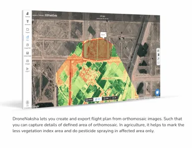
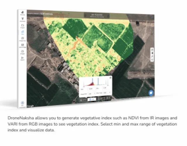
DroneNaksha enables crop analysis using RGB and Infrared images and various algorithms like VARI, NDVI. Agricultural purpose of inspecting plant health, survey and spraying can be effectively done with DroneNaksha.
Why should I use it?
Saas Model
DroneNaksha is offered as SaaS on Pay Per Consume model. No need to invest licensing cost.
Fast Processing
It is cloud powered with full scale parallel processing to reduce your processing time.
Higher Accuracy
Orthomosaic images ground distance 1.5 CM/pixel generated similarly DEM with 5 CM/pixel can be generated.
Any Workload
DroneNaksha architecture empowers it to process multiple images simultaneously.
AI Security
AeroMegh offers AeroCapture service which helps AI based analytics images generated by DroneNaksha.
One Stop Solution
DroneNaksha supported products AeroGCS KEA which helps flight plan & upload data DroneNaksha account.
Local Data Compliance
DroneNaksha offer local compliance to store your data in your region only local Government data policy.
Data Analytics
DroneNaksha SaaS Data security is important concern for the end to end solution offered by AeroMegh.


PDRL
Software
AeroMegh a cloud Platform - AeroGCS KEA a Drone Management Software, AeroGCS GREEN a Mission Planning and Precision Spraying software, DroneNaksha a Processing Software & PicStork an analytics Software
Software Solutions
Construction & Real Estate, Disaster Management / First Responders, Environment & Wildlife, Forestry & Agriculture, Infrastructure & Transport, Mining & Exploration, Power & Utilities, Surveillance & Mapping
India
-
PDRL is a Software Company offering AeroMegh as a SaaS platform for Transforming Drone Data into Actionable Insights. AeroMegh is designed to deliver an End-to-End stack for Flying and Capturing, Processing and Analyzing. AeroMegh allows to carry challenging tasks by saving important aspect of life, Time and Money by resulting in Creating More Time to Live.