Drone Sensors: A Complete Guide
Published by:Beyond Sky

 English
If a drone is the body, then its sensors are the eyes, ears, and reflexes. They see hear, feel movement, read terrain, and make sense of the sky in milliseconds. Without this layer of intelligence, UAVs would just be remote-controlled machines.
Drone sensors are what transform them into autonomous, data-gathering powerhouses used in everything from agriculture to defense.
Let’s talk pure Sensors and understand how emerging AI is changing the game for nextgen smart drones.
Every drone depends on its sensory suite for accurate flight and data capture. Sensors feed environmental inputs like altitude, position, light, temperature into the drone’s onboard systems so it can respond instantly.
Modern drone sensors aren’t just about navigation. They power advanced mapping, 3D modeling, object detection, and condition monitoring. They help drones stay stable in wind, scan pipelines for leaks, assess crop health, and even predict mechanical issues before takeoff.
In other words, sensors are the invisible intelligence behind every precise movement a UAV makes.
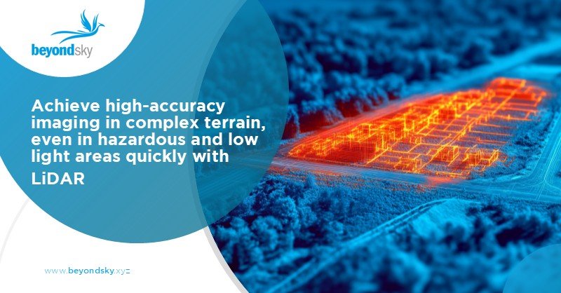
LiDAR (Light Detection and Ranging) is easily one of the most advanced sensing tools available for UAVs. It works by firing hundreds of thousands of laser pulses per second and measuring how long it takes for them to reflect back from surfaces. The result is a 3D point cloud, a highly accurate digital reconstruction of terrain or structures.
Paired with GNSS and IMU inputs, LiDAR sensors for drones can achieve centimeter-level accuracy, which is essential for civil engineering, infrastructure monitoring, and geospatial surveys.
Thermal imaging sensors measure heat instead of light. They turn temperature differences into color-coded visuals so operators can literally see heat signatures.
One strong example firefighting units around California now use drones equipped with thermal sensors to identify structural heat stress or hidden embers during wildfire containment. It’s safer, faster, and dramatically more efficient than sending human scouts into the flames.
Multispectral sensors capture data beyond what the eye can see into infrared, rededge, and nearUV wavelengths. They’re the go-to tool for precision agriculture.
By analyzing light absorption and reflection, these sensors can measure photosynthesis activity and detect unhealthy or water-stressed crops days before visible signs appear.
They’re also valuable in forestry and environmental tracking, providing detailed insight into vegetation cover, water content, and soil quality.
Drones use a fusion of GPS, GLONASS, IMUs (Inertial Measurement Units), barometers, and magnetometers to know exactly where they are, how they’re tilted, and how fast they’re moving.
These drone navigation sensors deliver stable flight and autonomous precision in mapping and surveying tasks. Advanced modules use RTK enabled GNSS technology for submeter accuracy, critical for defense, BVLOS, and industrial inspection.
When signals get weak, systems rely on IMU and compass data to maintain reference which is basically the UAV equivalent of “flying blind” using muscle memory and instinct.
So how do all these sensors talk to the drone? It’s surprisingly similar to how your own senses talk to your brain.
Example: In LiDAR mapping, the sensor calculates the time delay between laser emission and reflection to measure distance. With hundreds of thousands of these readings, the software builds a 3D contour map in real time. It’s fast enough for a drone flying at 20 m/s to capture terrain data within centimeters of accuracy.
Farm drones use multispectral and thermal cameras to catch irrigation or disease issues before they spread. Combining those readings with AI algorithms allows farmers to plan fertilizers or watering patterns for maximum yield.
LiDAR and thermal sensors monitor solar plants, wind turbines, and rail lines for structural faults or overheating. These drones replace manual inspection teams working at dangerous heights.
Search and rescue teams rely on thermal UAV sensors to locate missing people by their heat signatures. Law enforcement uses LiDAR mapping for accident reconstruction or tactical surveillance.
LiDAR sensors for drones generate contour maps within minutes, no ground survey crew required. Architects use this data for progress planning, volume measurement, and inventory management.
From monitoring borders to detecting movement in rough terrain, UAV sensors are now standard in surveillance and reconnaissance systems. They deliver data quietly, quickly, and accurately.
Here’s where things get really interesting. The next generation of sensors won’t just collect data, they’ll interpret it. AIpowered drone sensors already use edge computing to detect objects, interpret spectral data, and make navigation decisions on their own.
Think of smart UAV sensors that can:
If you’re building drones for realworld impact, BeyondSky features nextgen navigation and sensor modules that simplify highaccuracy UAV development.
A cutting edge multi GNSS tracker built for ultraprecise navigation. With RTK grade accuracy and full GPS, GLONASS, Galileo, and BeiDou support, it’s designed for UAVs that can’t afford positional drift.
This made in India sensor pushes globalgrade performance with compact hardware that weighs almost nothing but delivers industrial strength.
If GPS is the map, the Aeron Pollux is the inner ear. This inertial navigation system uses MEMS gyros and highquality sensors for unmatched flight stability, even when GPS signals drop.
Pollux powers UAVs used in energy, defense, and robotics, enabling consistent, accurate data flow in dynamic flight environments.
Both axl Orbit and Pollux 2 are available on BeyondSky today!
Drone sensor technology is evolving faster than ever. What started as simple cameras has grown into networks of intelligent sensors capable of perceiving the world in detail far beyond human eyes. LiDAR, thermal, multispectral, and navigation sensors now work in unison to give UAVs a cognitive edge.
As AI and onboard processing advance, drone sensors will define the next frontier in automation drones that not only fly smart but think smart. The ones that can plan routes, interpret environments, and make decisions without human help.
Drone sensors are essential for perception and control. They detect motion, altitude, obstacles, temperature, and environment data — allowing UAVs to navigate, stabilize, and perform automated operations safely and efficiently.
The most common drone sensors are LiDAR, GPS, IMUs (Inertial Measurement Units), barometers, magnetometers, thermal sensors, multispectral sensors, and ultrasonic sensors. Together, they handle flight, mapping, obstacle detection, and environmental analysis.
LiDAR (Light Detection and Ranging) emits laser pulses to scan surrounding surfaces, producing highly accurate 3D terrain models. It’s widely used in construction, mining, forestry, and defense due to its precision and ability to penetrate dense canopies.
Thermal sensors visualize heat, helping detect energy loss, overheating, and live subjects in rescue operations. Multispectral sensors measure reflected light in multiple wavelengths to track crop health, soil quality, and vegetation density.
IMUs detect movement, acceleration, and rotation, while GPS provides position tracking. Data from these sensors keeps the drone balanced, helps it plan routes, and ensures it remains on course even in wind or signal loss.
Ultrasonic, infrared, LiDAR, and radar sensors are used for obstacle avoidance. They measure distance from objects and trigger real-time corrections in the drone’s flight path to prevent crashes.
AI-powered sensors now process data on-board, recognizing threats, interpreting visual patterns, and autonomously adjusting flight response. This innovation enables drones to “think” in real time, optimizing their path and data quality without human input.