Inertial Navigation Systems (INS) for Drones
Published by:Beyond Sky
 English
Every drone mission depends on one thing - knowing exactly where the aircraft is. Without precise navigation, even the smartest drone can lose control or wander off course. Most UAVs lean on GPS for this, but GPS has its weak spots. Inside buildings, near tall structures, or under thick forest canopies, the signal fades or disappears.
That’s when Inertial Navigation Systems (INS) take over. INS keeps the drone aware of its position and movement without any external signal. It lets a drone “feel” how it’s moving through space using only sensors onboard. As drone operations expand into tougher environments and more autonomous roles, INS is becoming a key part of reliable flight.
At its core, an INS is a self-contained navigation unit that tracks a drone’s movement and orientation in real time. It’s built around three main sensors: accelerometers, gyroscopes, and sometimes magnetometers.
Accelerometers measure how fast the drone moves in a straight line. Gyroscopes measure how it rotates or tilts. Magnetometers, when included, help with directional reference. Together, they calculate how far and in what direction the drone moves.
Unlike GPS, which depends on satellites, an INS relies only on internal measurements. That independence makes it valuable in places where GPS doesn’t work, like mines, warehouses, or areas with heavy electromagnetic interference.
INS starts from a known point. Every fraction of a second, it measures acceleration and rotation. From that data, it estimates how far the drone has moved and in what direction.
Here’s a simple way to look at it:
1. The accelerometer senses motion.
2. The gyroscope senses rotation.
3. The system combines both to track movement in 3D space.
The flight controller then uses this information to keep the drone stable and aware of its orientation.
Over time, small sensor errors build up a problem called drift. The longer the drone flies, the more its estimated position can deviate from reality. That’s why INS is often combined with GPS or vision-based navigation. INS provides smooth, fast updates, while GPS corrects any long-term errors.
INS might not get much spotlight, but it quietly powers a lot of what makes drones stable and dependable.
INS might not get much spotlight, but it quietly powers a lot of what makes drones stable and dependable.
Like any technology, INS has trade-offs.
The biggest challenge is drift. Even tiny measurement errors can compound over time. Long flights need GPS or vision data to correct it.
High-end drones use fiber-optic or ring-laser gyroscopes — very accurate, but expensive. Smaller UAVs often use MEMS-based sensors. They’re cheaper, lighter, and good enough for most missions, though less precise.
Sensors can lose accuracy with temperature changes or vibration. Regular calibration helps keep data consistent. Some modern systems can self-calibrate mid-flight.
Vibration, shocks, and magnetic interference can distort readings. Engineers often use damping mounts and filtering software to reduce noise in the data.
Most professional drone navigation systems combine GPS and INS. It’s a partnership where each system covers the other’s weaknesses.
GPS provides absolute position. INS provides motion data between those GPS updates. The combination gives smooth and reliable navigation, even if one signal falters.
This merging process, known as sensor fusion, often uses algorithms like the Kalman filter. It continuously weighs and blends the data from both sources. When GPS glitches, the INS keeps things stable. When INS drifts, GPS snaps it back on course.
High-end drones go a step further by fusing data from cameras, LiDAR, and radar. This creates an even richer and more stable picture of the drone’s environment.
INS has moved from being a backup to being a central part of many UAV systems.
INS is evolving fast. New designs and smarter algorithms are making it lighter, cheaper, and more reliable.
These upgrades will make UAVs more capable, not just reacting to the environment, but understanding it.
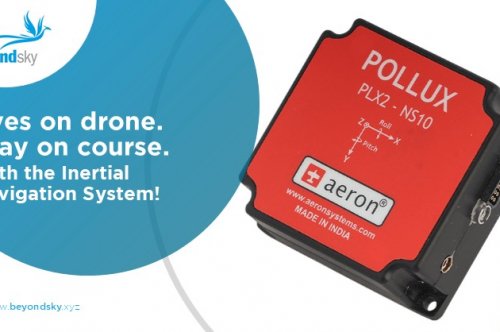
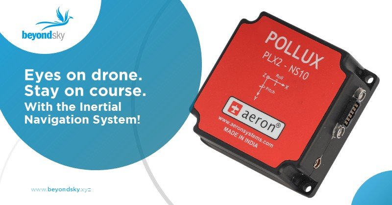
The Aeron Pollux 2 INS is a compact inertial navigation system designed for UAVs and autonomous platforms. It provides reliable position and velocity data even when GPS is unavailable, making it suitable for both indoor and outdoor operations. Its lightweight design and rugged build support stable flight and precise navigation for industrial and defense drones.
The axl Orbit-N GPS is a high-accuracy GNSS system built for UAVs, surveillance, and defense applications. It supports multiple satellite constellations for dependable navigation in complex environments. Its lightweight, durable design allows seamless integration into drones and other mission-critical platforms.
Beyond Sky offers these advanced drone navigation solutions and more in one platform. As a curated marketplace, it connects professionals with reliable UAV technology and verified manufacturers, providing a trusted source for drones and related components.
As drones move into more demanding roles, Inertial Navigation Systems are becoming central to how they fly. They make navigation more reliable, enable autonomy, and keep missions on track when GPS cannot.
For designers, operators, and researchers, understanding INS means understanding what gives drones their confidence in the air. It’s the quiet system behind every smooth, stable, and intelligent flight.
INS is a navigation tool that uses internal sensors accelerometers and gyroscopes to track a drone’s position, velocity, and orientation by measuring its movement relative to a known starting point without relying on external signals like GPS.
The INS constantly measures linear acceleration and rotation rates. It integrates these measurements over time to estimate the drone’s current position and attitude, updating the flight controller with real-time navigation data.
GPS signals can weaken or drop in enclosed, urban, or dense forest areas. INS provides continuous navigation data based on internal sensors, allowing drones to maintain stability and direction without external positioning aids.
INS offers high-frequency motion tracking, operates independently of GPS, enhances flight stability, provides redundant position data during GPS loss, and supports autonomous flight modes such as precise takeoff and landing.
Sensor fusion combines INS data with GPS and other sensor inputs using algorithms like the Kalman filter. This approach corrects INS drift using GPS fixes and smooths GPS noise using INS data, resulting in accurate and reliable drone navigation.
INS suffers from drift, where small errors accumulate over time. It requires precise calibration, is sensitive to temperature and vibration, adds cost and weight, and demands computational resources for data processing.
INS is vital for drones operating indoors, in tunnels, dense urban areas, GPS-jammed zones, defense missions, precision surveying, infrastructure inspection, and BVLOS operations where uninterrupted navigation is critical.