- Subscription Plans
- Favorite
- Help
-
 English
-
English


| RTK Accuracy | Centimeter level precision for exact positioning. |
| Fast RTK Fix | Achieves RTK fix in 10-60 seconds. |
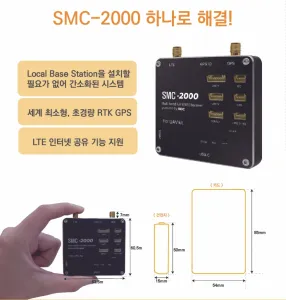
| Compact Size | Dimensions of 95 x 75 x 15 mm for easy integration |
| Lightweight Design | Weighs only 130g, enhancing drone performance. |
| Wide Temp Rang | Operates in -40? to 85? for versatile use. |
SMC 2000 UAV Kit is a cutting-edge RTK-enabled UAV solution delivering centimeter-level precision with ultra-low delay video transmission, ideal for precision agriculture and autonomous applications. With LTE support and fast RTK fix time, the SMC 2000 offers reliable, high-accuracy location services for the demands of the 4th Industrial Revolution.
Our Company
Synerex supplies receivers and related solutions for MBC's Broadcast RTK service that enables centimeter-class ultra-precision location information services. We will do our best to reach out to our customers with RTK GPS solution, which is the root of the 4th Industrial Revolution.
We would like to continuously research and develop IMU and INS applicable to precision agriculture and self-driving cars to localize them.
Also, we are widely distributing ultra-low delay video transmission technology that can be applied to construction machinery and autonomous driving, so please pay a lot of attention.
Synerex Inc. will always do its best to our customers.
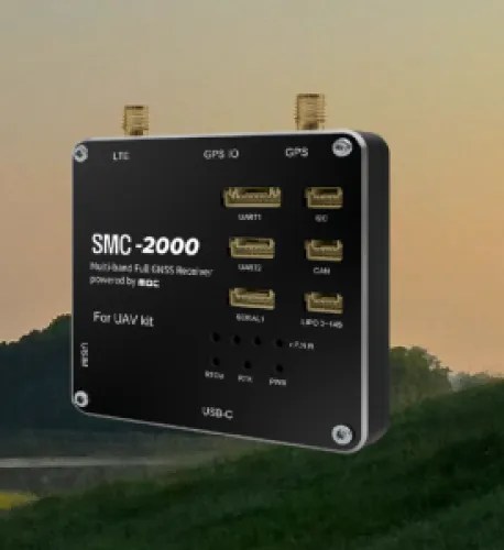
Our Product SMC 2000 UAV Kit
L1/L2 broadcast RTK data reception function
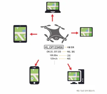
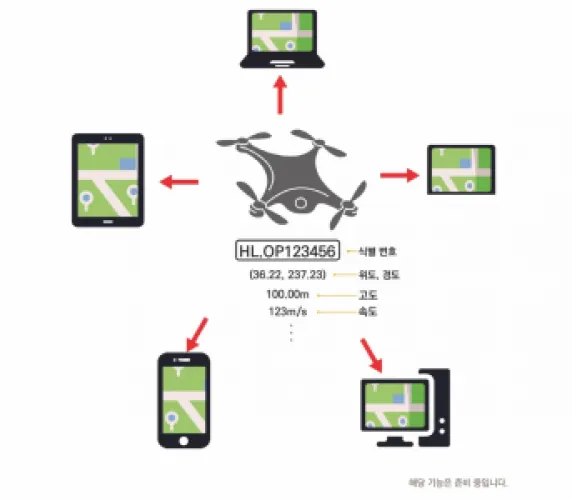
An RTK (Real-Time Kinematic) kit is a high-precision positioning system commonly used in drones and other equipment that require accurate geolocation. RTK technology enhances the accuracy of GPS data by using a reference station (often referred to as a base station) that provides real-time correction data to a mobile receiver, such as one on a drone. This setup significantly reduces positioning errors and can achieve accuracy down to the centimeter level, compared to the typical meter-level accuracy of standard GPS.
Components of an RTK Kit
An RTK kit generally consists of:
1. Base Station: A stationary receiver placed at a known location. It continuously receives GPS signals and calculates errors, which it then transmits to the rover.
2. Rover (Drone Receiver): This is installed on the drone and receives both GPS signals and correction data from the base station.
3. Communication Link: Usually a radio or cellular link that transmits correction data from the base station to the rover in real-time.
How RTK is Used in Drones
1. Precision Mapping and Surveying: RTK-equipped drones can capture highly accurate geospatial data, which is essential for mapping, land surveying, and construction. The centimeter-level accuracy helps in creating detailed maps and 3D models.
2. Agriculture: Farmers use RTK-equipped drones for precision agriculture, enabling them to monitor crop health, manage irrigation systems, and even plant seeds with great accuracy.
3. Inspection and Monitoring: RTK allows drones to navigate closely and accurately along infrastructure like power lines, pipelines, and bridges, providing detailed inspections with minimal errors.
4. Autonomous Flight Operations: RTK improves the accuracy of autonomous flight paths and navigation, essential for applications like delivery drones and other autonomous operations where precise location is crucial.
Advantages of Using an RTK Kit in Drones
- High Accuracy: Achieves centimeter-level precision, essential for professional applications.
- Real-Time Corrections: Provides immediate accuracy improvements, making it suitable for dynamic environments.
- Reduced Post-Processing: With real-time data corrections, RTK minimizes or eliminates the need for extensive post-processing of positioning data.
RTK kits have become essential in various drone applications where precision is a priority, enabling drones to perform tasks that require high accuracy and reliability.
Synerex
Hardware
SMC 2000 UAV Kit, SMC 2000 Robotic Kit, MRP 2000, MRP 2000v2, MRP 2000 UAV kit, MDU 2000, TDR 3000, MDR 1000v2
Manufacturer
Construction & Real Estate, Drone Delivery, Power & Utilities, Forestry & Agriculture, Surveillance & Mapping, Leisure & Hobby, Aerial Photography, Mining & Exploration, Education, Security & Law Enforcement, Environment & Wildlife, Archeology & Monuments, Disaster Management / First Responders, Infrastructure & Transport, Science & Research, Others, Insurance, Healthcare & Humanitarian Aid, Water Management, Urban Planning, Supply Chain & Logistics
South Korea
East Asia & Pacific, Europe & Central Asia, Latin America & Caribbean, Middle East & North Africa, North America, South Asia, Sub-Saharan Africa
Synerex provides receivers and related solutions for MBC's Broadcast RTK service, enabling centimeter-level ultra-precision location information services. We are committed to delivering RTK GPS solutions, a cornerstone of the 4th Industrial Revolution. We continuously research and develop IMU and INS technologies for precision agriculture and self-driving cars to enhance localization. Additionally, we distribute ultra-low latency video transmission technology applicable to construction machine


