- Subscription Plans
- Favorite
- Help
-
 English
-
English
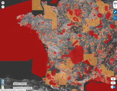


The DGAC, in conjunction with the IGN (Institut national de l'information géographique et forestière), has produced an interactive map of restrictions for recreational drones. This simplified, easy-to-understand map shows the zones between 0 and 120 meters throughout mainland France, in which flights by unmanned systems are subject to bans or restrictions
Geoportail Application Overview
The DGAC, in conjunction with the IGN (Institut national de l'information géographique et forestière), has produced an interactive map of restrictions for recreational drones. This simplified, easy-to-understand map shows the zones between 0 and 120 meters throughout mainland France, in which flights by unmanned systems are subject to bans or restrictions.
Map of Restrictions for the Open Category and Model Aircraft in Mainland France
This map is based on the decree of 3 December 2020 on the use of airspace by aircraft operating without a person on board. In areas where restrictions apply, flights are either completely prohibited or subject to specific authorization by the area manager. Flying in the open category without authorization is therefore not possible. In built-up areas, Open category drone flights are prohibited in public spaces.
Management of Geoportail
The DGAC (Direction générale de l'aviation civile) manages Geoportail in conjunction with the IGN (Institut national de l'information géographique et forestière).
Purpose and Audience of Geoportail
Geoportail is designed for recreational drone pilots and model aircraft enthusiasts. It helps users navigate airspace regulations and understand where they can and cannot fly.
Key Features of Geoportail
- Interactive Map: Displays zones between 0 and 120 meters where drone flights are restricted or prohibited.
- Regulatory Compliance: Aligns with the decree of 3 December 2020 and Commission Implementing Regulation (EU) 2019/947.
- Support Contact: Users can contact the support team at dgac-carte-drones@aviation-civile.gouv.fr.
Regulatory Compliance and Usage Guidelines
The use of this map should complement, not replace, a good knowledge of the regulations. It is essential to consult the "Open category" guide.
Current Limitations of the Geoportail Map
Although this map provides an extensive overview of space restrictions, users' attention is drawn to certain current limitations:
- Private helipads are not included in the current version.
- Temporary bans on flying over natural areas during nesting periods are not shown.
Additional Resources for Temporary Flight Restrictions
In general, for all areas created on a temporary basis, the Aeronautical Information Service website should be consulted.
Map of Restrictions in French Polynesia
For French Polynesia, the map of restrictions on the main islands of the Society archipelago is available here: dronix map - restrictions on drone use in French Polynesia.
Publication of Geographical Areas for Unmanned Aircraft in France
Commission Implementing Regulation (EU) 2019/947 of 24 May 2019 on rules and procedures applicable to the operation of unmanned aircraft provides in Article 15 that information on geographical areas for unmanned aircraft established for geo-vigilance purposes be made public by States in a single, common digital format.
Special Conditions and Geographical Zones
A geographical area is a part of the airspace in which special conditions apply to the operation of UAS for reasons of safety, privacy and protection of personal data, security, or the environment. In France, including its overseas departments and communities, these conditions are set out in regulations, including the decree of 3 December 2020 on the use of airspace by unmanned aircraft. Geographical zones can include controlled airspace, restricted or prohibited zones, national park cores, or zones indicating the presence of an establishment prohibiting low-level overflight.
Electronic and Illuminated Signs Regulations
Decree no. 2019-1114 of 30 October 2019 and the Order of 27 December 2019 define the technical characteristics of electronic and illuminated warning devices for aircraft operating without a person on board.
Exemptions for Certain Aircraft and Pilots
Unmanned aircraft (drones and scale models) weighing more than 800 grams must issue an electronic warning. The obligation to issue a warning light applies only to aircraft flying at night. Aircraft used for leisure purposes by a remote pilot who is a member of an association affiliated with the FFAM or the UFOLEP, and certain model aircraft sites, are exempt from these obligations.
Procedures for Compliance and Registration
The CERFA n° 15963*01 form is available for download for applying for a manufacturer's identifier for unmanned aircraft or electronic reporting devices. The AlphaTango portal incorporates the ability to enter the identification number of the electronic reporting device for aircraft without a person on board.
Important Notes on Electronic Reporting Device Identification
Only the manufacturer of the unmanned aircraft or removable electronic reporting device can provide the identification number. If this information has not been explicitly provided, users should contact the manufacturer to obtain it. Incorrect information can result in penalties as set out in Decree no. 2019-1253 of 28 November 2019.
Summary of Relevant Decrees and Orders
- Decree no. 2019-1114 of 30 October 2019
- Decree no. 2020-575 of 14 May 2020
- Decree no. 2019-1253 of 28 November 2019
Final Considerations for Remote Pilots
It is the responsibility of the remote pilot to ensure compliance with current regulations, especially regarding bans on overflights below a certain height, which apply in national airspace. The first catalogue of information relating to geographical areas is available in EUROCAE ED-269 format on the SIA website, accompanied by an explanatory note.

Géoportail
Regulations
Geoportail
Regulatory Body
Construction & Real Estate, Drone Delivery, Power & Utilities, Forestry & Agriculture, Surveillance & Mapping, Leisure & Hobby, Aerial Photography, Mining & Exploration, Education, Security & Law Enforcement, Environment & Wildlife, Archeology & Monuments, Disaster Management / First Responders, Infrastructure & Transport, Science & Research, Others, Insurance, Healthcare & Humanitarian Aid, Water Management, Urban Planning, Supply Chain & Logistics
France
France
The DGAC, in conjunction with the IGN (Institut national de l'information géographique et forestière), has produced an interactive map of restrictions for recreational drones. This simplified, easy-to-understand map shows the zones between 0 and 120m, throughout mainland France, in which flights by unmanned systems are subject to bans or restrictions.

